Slea Head Drive, one of Ireland’s most scenic routes, takes you on a journey through historic sites, Irish speaking villages, famous Hollywood film locations with close up views of the world renowned Blasket Islands and distant views of the Skellig Islands on the south western horizon.
The Slea Head Drive (Slí Cheann Sléibhe) is a circular route, forming part of the Wild Atlantic Way, beginning and ending in Dingle, that takes in a large number of attractions and stunning views on the western end of the Dingle Peninsula. The route is clearly labelled by road signs throughout its length. The Slea Head Route is most enjoyable when done slowly over a number of hours or days allowing time for the many interesting stops and detours along the way. A minimum of a half-day should be set aside for the journey.
Travellers are strongly advised to travel clockwise in order to avoid meeting the large tour buses that frequent the route during the summer. Part of the Slea Head cliff road is very narrow and single lane only. The route is suitable for motorists, but is also enjoyed by cyclists - bicycles can be hired at a number of locations in Dingle.
Route Guide
Dingle to Ventry - Ceann Trá
On leaving Dingle follow the signs for Slea Head Drive R559 in the direction of Ceann Trá - Ventry. The Drive passes over Milltown Bridge, past the woodlands at Burnham to the seaside village of Ventry - Ceann Trá. The long, curved strand is a blue flag beach and offers a safe venue for bathing and water sports.
Ventry - Ceann Trá to Fahan
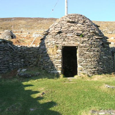
On leaving Ventry the Drive continues westward, past the remains of Dunbeg Fort, and the Fahan group of Clocháns or Beehive huts. there ar a number of small parking areas where you can stop to enjoy the view and visit some of these historic sites. On a clear day you can see the island of Skellig Michael as a silhouette on the southern horizon. The drive continues with a sheer cliff on one side and the Atlantic Ocean on the other. At Fahan hairpin bend the road crosses a ford.
Fahan to Slea Head
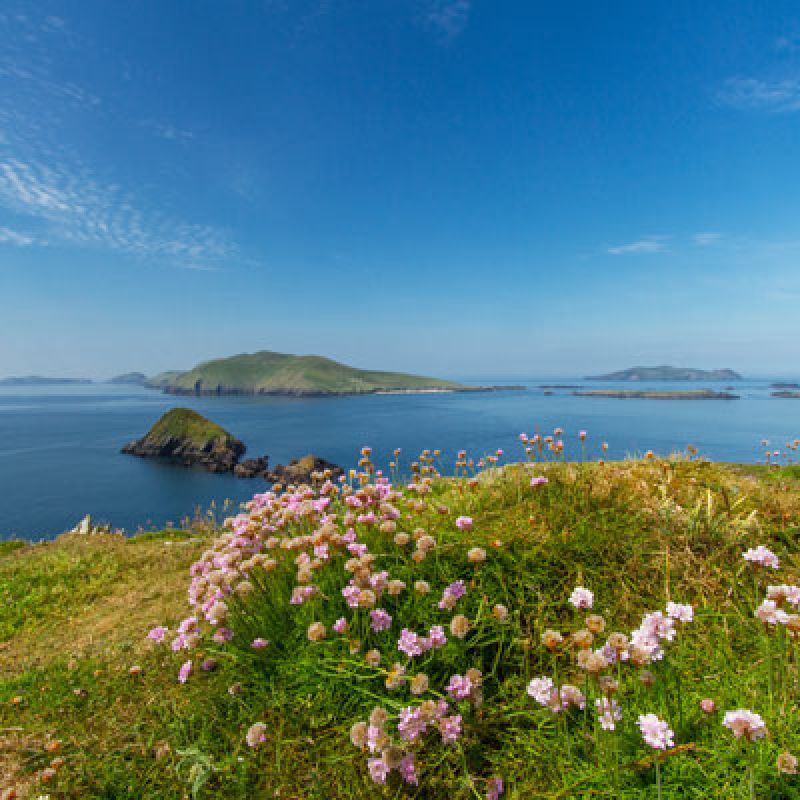
The Drive now reaches Slea Head itself, marked by a stone crucifixion scene, with dramatic views to South Kerry and the Blasket Islands.
Dún Chaoin / Dunquin to Baile an Fheirtéaraigh / Ballyferriter
The Drive continues north and east from Dún Chaoin through wild open countryside, passing Clogher Head and a great viewing point for Ceann Sibéal (both film locations) From here the road moves inland to the village of Baile an Fheirtéaraigh / Ballyferriter. The village has a number of bars, a shop and is the site of the Corca Dhuibhne Regional Museum.
Baile an Fheirtéaraigh to Baile na nGall / Ballydavid
The Drive now moves eastward, passing close to a number of ancient monuments, such as the excavated early Christian site at Reasc, and Gallarus Oratory. The traveller will next arrive at the fishing village of Baile na nGall/Ballydavid. On leaving the village the drive again follows a cliff-top route, with a dramatic seascape of crashing waves, rocks and seabirds below.
Baile na nGall / Ballydavid to Dingle
At An Fheothanach/Feohanagh a bridge is crossed and the route brings you to Cuas an Bhodaigh or Brandon Creek. This inlet was the legendary starting point of the voyage of St Brendan to America, centuries before Columbus. The Drive now turns south and runs along the base of Mount Brandon, the second highest mountain in Ireland. A pilgrimage route to the mountain's summit begins near here. The Drive now rejoins the main road south to Dingle, passing over a hill's crest at Ballinlochaigh and arriving back at the entrance to the town.
Driving Slea Head - Tips & Advice
Drive on the left side of the road.
Enjoy the Slea Head Drive by following the signs for ‘Slea Head Drive’ and ‘Wild Atlantic Way’ and travel in a clockwise direction.
Follow road signage first instead of being guided by your Sat. Nav. when using the Slea Head Drive and the Conor Pass. The local signs are to ensure free flow of traffic.
Walkers and Cyclists use our roads too. Please respect walkers and cyclists and pass with care giving them the safety of a 1.5 metre clearance.
Our road network on the Dingle Peninsula is full of charm but can be busy during the summer season. The roads are often narrow at points, so allow for longer journey times.
There are lay-bys where you are asked to pull in to let traffic through should a tailback have developed.
Other road users include farmers with cows and sheep on the roads. Please take due care and allow them to herd their stock safely. In the event of sheep on the road, please slow down and allow them to find their way back on to the hills or into fields.
Equestrian activities occur across the peninsula. Please slow down, give safe clearance and allow them to carry on in safety.
There are a number of schools located along the route so please be mindful for the safety of school children.
Dispose or recycle your litter - “If You Bring It In, Take It Out” please.
Slea Head Drive on the Dingle Peninsula
52.1408,-10.2908
Dingle Town
Start and end point of Slea Head Drive
52.1338,-10.3639
Ventry - Ceann Trá
52.0976,-10.4514
Slea Head
52.1663,-10.4061
Ballyferriter
Providers
Directory links to related businesses, events and providers on the Dingle Peninsula
Select a Slea Head Experience
Become part of our stories... share your experience of Slea Head with us by using #DinglePeninsula
Notice: Undefined variable: prefix in /home/dinglepe/new.dingle-peninsula.ie/templates/yootheme/vendor/yootheme/builder/elements/layout/templates/template.php on line 3
Geography of the Dingle Peninsula
tíreolaíocht - geography
The most northerly of the major peninsulas on the southwest coast of Ireland, the Dingle Peninsula or Corca Dhuibhne stretches 30 miles (48 kilometres) into the Atlantic Ocean from Ireland's south-west coast.
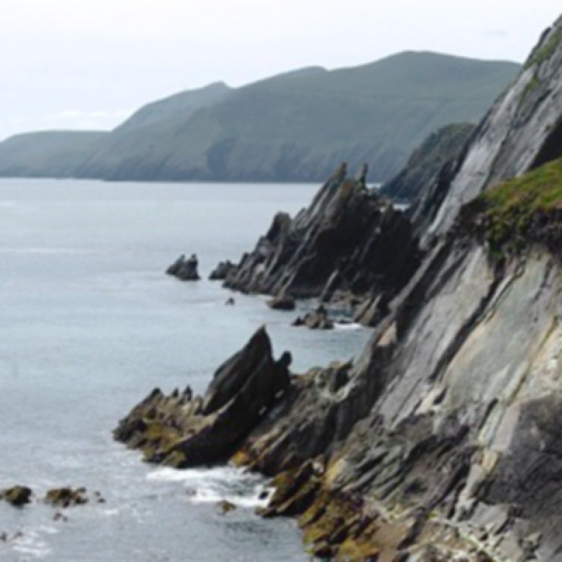
The peninsula is dominated by the range of mountains that form its spine, running from the Slieve Mish range in the east to the Brandon range in the northwest and Mount Brandon Cnoc Bréanainn 952 m. On the southwest of the peninsula and connected to the Brandon range with lower hills are Mount Eagle Sliabh an Iolair 461m, the sea cliffs of Slea Head and Dunmore Head reputedly the most westerly point of Ireland and Europe. This unique landscape is primarily due to the wide diversity of geological rock formations and structures formed through 485 million years of Earth history.
The Peninsula is known for its spectacular scenery and dramatic contrasts. Rugged rock and cliff meet crashing Atlantic Waves, steep mountain passes with vertiginous cliffs rise into the mist and cloud. Sheltered coves and golden sandy beaches give way to soft rolling hills and a mosaic patchwork of irregular small fields divided by low stone walls.
history and landscape
The Dingle Peninsula has supported various tribes and populations for almost 6,000 years. Because of the peninsula's remote location, and lack of specialised agriculture, there is a remarkable preservation of over 2,000 historical monuments in the landscape such as standing stones, forts and small buildings. Over the centuries small scale tillage farming involved removing the plentiful stones and rocks from the ground in order to plant crops. These stones were used to build dry stone walls dividing fields, creating small roads and homesteads.These walls,small settlements and field patterns are still in evidence in many areas across the Peninsula. The stone of the Dingle Peninsula became part of the vernacular architecture with loose rubble and dry masonry walls still a feature of buildings in West Kerry. When the population reached a peak during the 19th century higher ground was intensively tilled to supply food. In strong sunlight you can still see the lines of potato ridges - known as ‘lazy beds’ abandoned after the Great Famine of the 1840s.
Way of life
Traditional farming, fishing and tourism are the main industries of Corca Dhuibhne / the Dingle Peninsula. Whilst farming is made up of mostly small holdings and fishing now mostly inshore, tourism is now the Number one industry and employer on the Dingle Peninsula. It has a short peak tourist season of approx. 3 months and it is made up for the most part of small local family run businesses. There is a population of approx. 10,000 people of which 2,050 live in Daingean Uí Chúis / Dingle Town.
Population
The population of the Dingle Peninsula is approximately 10,000 people of which 2,050 live in Daingean Uí Chúis / Dingle Town.
Articles
Click on an article below to read more about the climate, weather, geology, flora and fauna, coastlines and islands of the Dingle Peninsula.
"descending the Conor Pass down into Dingle Town can feel more like landing a light aircraft than driving"
The Conor Pass is one of the highest mountain passes in Ireland, and provides the most dramatic and scenic way of crossing from the north to south coast of the Dingle Peninsula. This narrow, twisting road runs for 12kms between the town of Dingle on the south and Kilmore Cross on the north of the peninsula, where roads fork to Cloghane/Brandon or Castlegregory. The views from the road are breathtaking, with a glaciated landscape of mountains, corrie lakes and a broad sweeping valley spread out below.
At the steepest part the road weaves its way around sharp cliff faces and passes high corrie lakes. There are some very narrow sections where two cars cannot pass, so drivers need to keep their eyes peeled when driving and be ready to stop at the wider sections. Vehicles over two tonnes in weight are prohibited from using the Conor Pass to avoid difficulties in passing other vehicles. A guide to driving the Conor Pass can be found here.
There are two main viewing stops, one at Peddlar's Lake on the north side and the other at the top. From the scenic car park at the summit there are fantastic views north and south of the Dingle Peninsula along the Wild Atlantic Way.
Pedlar's Lake
lough Doon Corrie lake
Lough Doon (locally known as Pedlar’s Lake) is a glacial corrie lake that sits above the road on the north side of the Conor Pass. Beneath the lake is the Conor Pass waterfall with a small car park and viewing area. The lake is accessed by clambering up a small rock path above the car park. This is the most accessible place to study the glaciated mountain scenery of the Dingle Peninsula. You can see the glacially striated rock lip of the corrie lake and boulder strewn moraines, a moraine-dammed lake and a kettle hole lake in the wide U shaped valley below.
Conor Pass Car Park
view point on the Wild Atlantic Way
At the highest point of the Conor Pass there is a small car park where you can stop and admire the dramatic view. This is considered one of the iconic viewing points of the Wild Atlantic Way. From here looking south you can see across Dingle Bay to the Iveragh peninsula, Ring of Kerry and out to sea the Skellig Rocks. Looking to the North is Kerry Head and Loop Head Co.Clare. Occasionally in very clear weather it is possible to see the Aran Islands off Co.Galway. Remember to bring a warm layer as the temperature is always a few degrees cooler at the top.
Conor Pass Waterfall
Rain, Fog and Mist
Driving the Conor Pass in rain, fog and mist is a very different but exhilarating experience. Long distance views disappear as you literally drive up into the clouds. Surrounded by steep cliff faces and dripping overhanging rocks the Conor Pass can be magical in these conditions - with only the narrow winding road and a few sheep for company you drive through an ancient landscape as if lost in the mists of time. After heavy rain, large volumes of water run down the mountains in streams and waterfalls. The road brings you close to one of these waterfalls on the north side of the pass.
Advice For Driving The Conor Pass - An Chonair
The Conor Pass is a mountain pass with length (max. 7.2m) and weight restrictions (max 2 tonnes). Vehicles greater than 2 tonnes in weight are not permitted to travel north-east of the car park at the summit of the Conor Pass. Vehicles such as coaches, caravans, camper vans and trucks cannot use the pass as they will not get through.
The first 2 km descent of the Conor Pass towards Cloghane Brandon, Castlegregory and Camp is narrow with several lay-bys to allow traffic to pass. Please yield beside lay-bys to allow any oncoming vehicles to pass with ease.
The final 2 km ascent of the Conor Pass from Cloghane Brandon, Castlegregory and Camp is narrow with several lay-bys to allow traffic to pass. Signage is in place to advise of their location. Please pull in when you see on coming vehicles.
The Conor Pass is not suitable for HGVs. Whilst vehicles can get to the summit of the Conor Pass from Dingle Town, the road from the Summit to Cloghane Brandon, Castlegregory and Camp is not accessible to any vehicle over 2 tonnes.
Use fog lights when driving in poor visibility and watch out for the signs that indicate how far motorists have to travel to the next passing bay.
For more advice on driving the Dingle Peninsula please see Driving on the Dingle Peninsula or you can download our driving guide in PDF format here.
Notice: Undefined variable: prefix in /home/dinglepe/new.dingle-peninsula.ie/templates/yootheme/vendor/yootheme/builder/elements/layout/templates/template.php on line 3
BEACHES OF THE DINGLE PENINSULA
coise sa ghaineamh - footprint in the sand
The Dingle Peninsula boasts some of Europe's most stunning beaches. From the spectacular sweeping curve of Brandon Bay, the seemingly endless sea and sky of Inch, to the many secluded and hidden sandy coves the Peninsula has been gifted by Mother nature. You can easily find a deserted beach with nothing but the sound of the ocean and crying gulls for company.
Surf dramatic breakers, dive and swim in azure Atlantic waters, run along a deserted bay, paddle barefoot at sunset, picnic and make sandcastles or simply breathe and enjoy the view on beaches you will never forget. Below is a guide to some of the fantastic beaches and coves of the Dingle Peninsula.
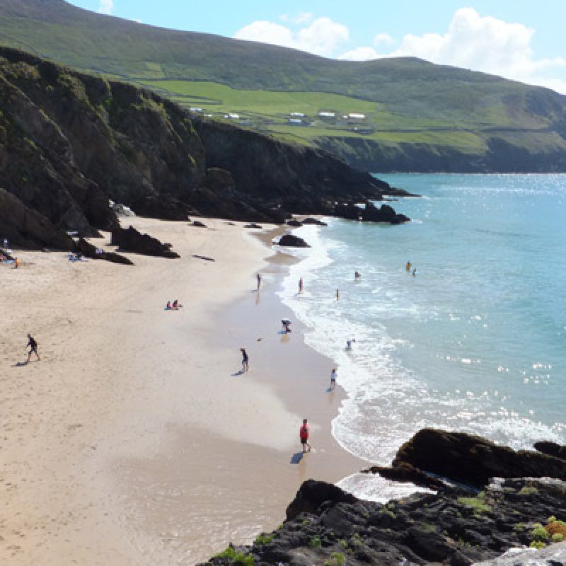
COUMEENOLE
Tucked under high cliffs and looking out to the deserted Blasket Islands this is one of the most iconic beaches on the Dingle Peninsula. One of the filming locations for Ryan's Daughter, Coumeenole is a popular stop for travellers on the Slea Head Drive.
Crashing waves, cliffs, sea spray and pristine clean sand make this a great place to get away from the world. There is a car park at the top of the cliff and a steep walk down a small road - remember you have to come back up!
Beautiful and dramatic this small cove catches the full force of the Atlantic and strong currents make it unsafe for swimming.
VENTRY - CEANN TRÁ
This Blue Flag beach is very popular with locals and visitors. Safe for children and swimming, this car-free beach is a great place to make sandcastles and relax. Generations of families return year after year to enjoy the gentle calm of this sheltered bay. A crescent of white sand approximately 3km long backs onto a small dune system, a small lake, wet grasslands and an extensive Common Reed swamp. A small pier lies at the Ventry village end. Car access is just beyond the village of Ventry with a car park, public toilets and a summer lifeguard station. See information board for times.
brandon bay
Sometimes described as the longest beach in Ireland the golden sandy beach that stretches around Brandon Bay from Cloghane under Mount Brandon to Fahamore in the Maharees on the northern side of the peninsula, has a number of beaches which are popular with swimmers, anglers, water sports enthusiasts and walkers.The Brandon Bay beaches are open to the North Atlantic and often receive long rolling swells, which can provide excellent surf given suitable wind and tide conditions.
Cappagh Strand/ Trá an Cheapaigh is adjacent to Cloghane Village.
Fermoyle Strand/Trá Fhormaoileach is a sandy beach near the village of Cloghane. Ideal for walking, swimming, angling, surfing and other watersports.
Kilcummin, Stradbally and Gowlane Strands: With miles of unbroken sand beaches this area is popular with surfers, windsurfers and kitesurfers.
.
Béal Bán and Wine Strand
Béal Bán and Wine Strand/Trá an Fhíona: these popular beaches are close to the village of Ballyferriter/Baile an Fheirtéaraigh.
Both beaches are sandy, safe for swimming and provide stunning views. In June of each year an impromptu horse-racing festival is held at Béal Ban, with associated events in the public houses of Ballyferriter.
THe Maharees
An extensive sand spit and associated dune system to the north of Castlegregory village. There are a number of beautiful sandy beaches on this tombola. Magherabeg or Maharbeg has a blue flag and has lifeguards during the summer season.
The Maharees beaches are very popular for watersports and a number of surfing schools operate in the area.
INCH BEACH
Inch or An Inse is an impressive Blue Flag beach. A wild and wind-swept dune system stretches along this amazing sand spit as it reaches out into Dingle Bay towards Rossbeigh Beach on the Iveragh Peninsula. Rising behind Inch are the Slieve Mish Mountains which form the backbone of the Dingle Peninsula. Inch beach is very popular with adventure sports enthusiasts such as wind, wave and land surfers, anglers and swimmers. There are life guards on patrol during the summer season and local surf schools provide lessons, water sports equipment and wetsuit hire on the beach.
Beaches on the Dingle Peninsula
Blue Flag beaches on the Dingle Peninsula with safe swimming are Inch, Ventry and Maherabeg. Brandon Bay near Castlegregory is the place to head for windsurfing on the Dingle Peninsula. The place is legendary amongst windsurfers.
Brandon Bay
52.2623,-10.0772
Coumeenole
52.1099,-10.4648
Ventry Beach
52.1323,-10.3656
Inch Beach
52.1417,-9.9828
Maherabeg
52.2854,-10.0345
Béál Bán
52.1937,-10.4144
The Maharees
An extensive sand spit and associated dune system to the north of Castlegregory village. The beaches have a blue flag and have lifeguards during the summer season.
A number of surfing schools operate in the area.
52.2887,-10.0254
Beach Activity Providers
Directory links to related businesses, events and providers on the Dingle Peninsula
Become part of our stories by using #DinglePeninsula and @dinglepeninsulatourism when you post